

More details about CaveMeter
To get good results the Compass must be calibrated.
Just hold the smartphone in your Hand, start the app and perform two or three times a rolling lying eight.
 An earlier version of cavemeter must eventually be deinstalled before.
And "Allow installation of apps from unknown sources" in the configuration of your smartphone.
The version in Google Play Store (1.0.12) 2. June 2014 is obsolete.
I'm sorry, but I can no longer update it since Google Play Developer Program Policy demands of me to subdue to American Export Administration Regulation, which I can not do.
These are so many files, I am unable to read them all. Not to mention understand them.
Unfortunately Google refuses to delete my account and hassles with many pointless "policy updates".
 Frequently Asked Questions:
Clinometer
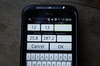
- Why is there -90 in "Adj. Vertical"?
Cavers use two different ways to note declination. Some (e.g. Sunto) define horizontal as 0 degrees. Upwards they count positive till plus 90, downwards they use negative numbers. (This is the default in CaveMeter and the reason for the "-90".) The others are afraid of getting confused with writing plus and minus and define horizontal as 90 degrees. Upwards they increase the numbers till 180, downwards they decrease. So a vertical pit has 0 degrees. (If you want that just change the -90 in "Adj. Vertical" to 0.) - How to adjust the declination?
Take a bearing over a point A to B and afterward vice versa from B to A. Add the two declinations and divide the result by minus two, e.g:
+8.0 plus -6.4 = +1.6
+1.6 / -2 = -0.8
"Menue" > "Adj. Vertical" and type in the right field (Additional) -0.8 - How precise ist the clinometer?
Results should be clearly better then +/- 1 degree.
Compass
- How to calibrate the compass?
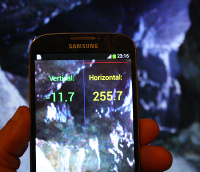
The compass ist calibrated continuously during use. Before starting a measure you should in addition make the movement of a lying eight link in the video. - How to adjust the compass?
If you find out that the compass systematically shows e.g. 2.5 degrees too much, then start "Menue" < "Declination-GPS" and type the correction -2.5 in the appropriate field. There you can also compute magnetic declination on the basis of GPS. - What is magnetic declination?
The Compass does not point to North but to the magnetic north pole, which is at the time (2013) about 500 km away from geographic north pole. Depending on your present position on earth the difference between geographic and magnetic direction to north is different. In many parts of Canada it is more than 20 degrees. This difference is called magnetic declination.
According to geologic standards it is changing rapidly. For example: 1983 magnetic declination near Berchtesgaden in Germany was zero degrees and could simply be ignored. 2012 it was +2.7 degrees. That means, when the compass showed 90.0 degrees, geographic direction was 92.7 degrees.
Declination at your present position is determined with menu item Declination in CaveMeter (GPS must be activated): Wait until present position is displayed. Then press Compute. Declination is displayed in the left upper corner. If now you press Save, the value is stored and will be used for further calculation of direction. - How precise ist the compass?
Results should be about +/- 2 degrees. But spikes may happen. The shorter the red bar, the more precise is the compass. - Are there any reference points even without map?
Menu -> Direction, and wait until GPS button can be used. Click it and wait until Accuracy shows values as low as possible. Click Save button to save your present position and move away as far as possible. From one kilometer or more reasonable values can be expected.The value below "Save" shows the geographic direction to the saved point. Calibrate the compass like in the video and correct deviation in Menu -> Declination.
Results
- Where are the results of the measures?
The results are saved in the folder "cavemeter". If you did not enter a cavename the files name is "cave.txt", otherwise it is the name you entered. If no extension .txt was stated it will be added automatically by the program. So it is easier to copy and paste survey data to a program for drawing the map. - How to draw a map of the cave?
The results are saved in pure text and can be used without any changes by copy&paste in programs for drawing cave maps like Therion or copycave.